Student’s app studies Twitter location trends
A USC graduate student has developed an app to analyze Twitter users’ geospatial data.
Chris Weidemann, a graduate student in the USC Dornsife College of Letters, Arts and Sciences’ online Geographic Information Science and Technology master’s program, has studied how much public geospatial data is created by Twitter users, and how others could use this information. Weidemann recently published his findings in the International Journal of Geoinformatics.
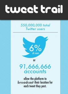
About 6 percent of users have allowed Twitter to display their geospatial data, while others have permitted Twitter to publicly display their hometowns and time zones. Even for users with stricter privacy settings, information about location can be gleaned from the tweets themselves.
In order to get a more accurate depiction of what this data could show about tweeters’ locations and the tweeters themselves, Weidemann created Twitter2GIS, an application that analyzes geospatial data made by Twitter users.
“My intent is to educate social media users and inform the public about their privacy,” Weidemann told USC News.
According to the app’s data, a little more than 2 percent of tweets provided location data in the text of the tweets, while about four million users’ locations were revealed through the global positioning system.
Though this geospatial information could aid with marketing for corporations, it could also provide more opportunities for those with criminal intent.
As part of his master’s thesis, Weidemann is planning on expanding his application so that Twitter users will be able to see their own geospatial data. Right now, users can test out the application at Geosocialfootprint.com, but Weidemann will be working to improve the application throughout the rest of the year.
“This research has been fun,” Weidemann said, then added, “And a little scary.”
Follow Alexandria on Twitter @alimar18

